Precipitation and the Inter Tropical Convergence Zone (ITCZ)
The most important component of climate is precipitation, because rainfall provides water for survival. Equatorial regions have extremely regular annual and inter-annual (short-term and long-term) patterns of rainfall. These regions include the rain forest areas of Cote d'Ivoire, Ghana, Togo, Cameroon, the Central African Republic, and parts of both the Congo and the Democratic Republic of the Congo. These regions have between 8 and 12 months where rainfall is >50 mm/month and as many as 200 days of precipitation each year, making the equatorial zone the wettest on the planet. The equatorial region has no real dry season and is constantly hot and humid. This idea should sound familiar to you, because the White Nile starts in the equatorial region, and it does not have a major flood season.
As distance from the equator increases, the duration, amount and reliability of precipitation all decrease. As a result, agricultural enterprises of any type become a riskier business as one moves away from the equator. The extreme, of course, is the Sahara desert in northern Africa.
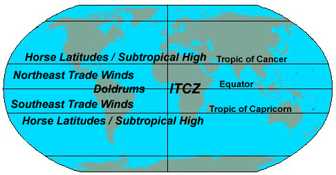
So what causes the rain to fall at the equator but not in the higher latitudes? To answer that question we need to look at the movement of air around the Earth. On a large scale, there are few air masses which shape the rainfall characteristics of tropical Africa. Sub-Saharan Africa (excluding the East African coast) gets its precipitation from tropical moist oceanic air that moves from the Atlantic and Indian Oceans toward an equatorial low pressure zone. This area is the intertropical convergence zone (ITCZ). The ITCZ is also called the "climate equator"—it lies near the geographic equator, and divides the global air circulation patterns into two mirror images to the north and south. The ITCZ is an area of low atmospheric pressure that forms where the Northeast Trade Winds meet the Southeast Trade Winds near (actually just north of) the earth's equator.
Air Masses. Source: http://geography.about.com/library/weekly/aa050301a.htm
As these winds converge, moist air is forced upward, forming one portion of the Hadley cell. The air cools and rises (see image below), causing water vapor to be "squeezed" out as rain, resulting in a band of heavy precipitation around the globe. Air that rises along the ITCZ moves away from the equator and sinks in the subtropics at the Horse Latitudes, rounding out the Hadley Circulation. This reliable circulation feeds the lush rain forests of central Africa, and also defines the limits of the Sahara desert. The ITCZ has been called the doldrums by sailors because there is essentially no horizontal air movement, that is, no wind (the air simply rises). In the US, we are interested in the ITCZ primarily because, under certain circumstances, tropical depressions moving along the ITCZ intensify to hurricanes.
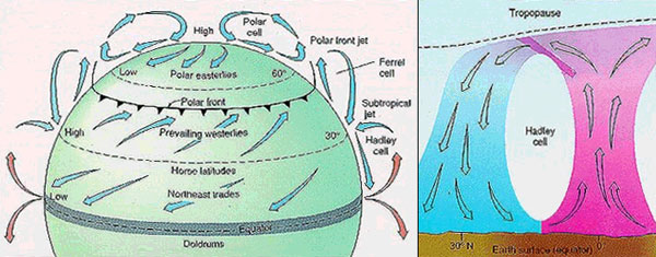
Hadley Circulation. Source: http://sparce.evac.ou.edu/q_and_a/air_circulation.htm
The position of the ITCZ varies predictably throughout the year. Although it remains near the equator, the ITCZ moves farther north or south over land than over the oceans because it is drawn toward areas of the warmest surface temperatures. The location of the ITCZ can vary as much as 40° to 45° of latitude north or south of the equator on land. It moves toward the Southern Hemisphere from September through February and reverses direction in preparation for Northern Hemisphere Summer. The ITCZ is less mobile over the ocean, although there is one exception: during an El Nino event the ITCZ is deflected toward the unusually warm sea surface temperatures in the tropical Pacific. Thus the position and migration of the ITCZ are important in defining the Earth's climate on a global scale.
So how does it work in Africa? The ITCZ migrates latitudinally on a seasonal basis. In July, when the sun is over the Tropic of Cancer, the ITCZ reaches its northernmost position at about 15°N; in January it reaches ~5° S when the sun is over the Tropic of Capricorn. The most important consequence of this shifting is the annual alteration of wet and dry seasons in tropical Africa.
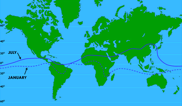
Annual movement of the intertropical convergence zone (ITCZ). Source: http://geography.about.com/library/weekly/aa050301a.htm
Areas near the equator in western and southern Africa have a single intense rainy season from July to September. In eastern Africa (S. Ethiopia to central Tanzania), however, there are two rainy seasons. The ITCZ moves northward over this region between February and May, and southward again between October and December. Since the distance covered by the ITCZ is quite large in this part of the continent, the rainy seasons are less intense than those of western Africa. That is, the ITCZ dumps the same amount of rain in the east as it does in the west, but that rain gets distributed over a larger area in the east because of the greater movement of the weather system.
The arid and semi-arid regions of Africa (Sahara and Sahel) lie north of about 10°N, near the northern limit of the ITCZ, and receive one rainy season with very little precipitation. Farther to the north, along the Mediterranean Sea coast, the climate is not affected directly by the ITCZ and rain falls in the winter.
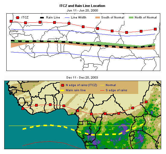
Intertropical convergence zone (ITCZ) and rain location. Source: ADDS, the African Data Dissemination Service
Note: Please click on the image to see a larger version.
What
do YOU think? ITCZ and hurricanes
Based on what you have just learned about the ITCZ, how does that tie into the USA's hurricane season? Post your thoughts and opinions to the Lesson 07 Discussion Forum (That discussion forum can be accessed at any time by clicking on the Communicate tab in ANGEL and then looking in the Discussion Forums box.)