COURSE SYLLABUS FOR GEOSC 297a - SPRING 2007
Instructor
Dr. Andrew Nyblade
- Office: 447 Deike; Lab 444 Deike
- Email: Please use ANGEL's e-mail client (under the In Touch tab) - http://cms.psu.edu
- Phone: 863-8341
- Office hours: Open door policy - feel free to stop by or to call for an appointment
I was born and raised in Tanzania, and I have spent the better part of the past 20 years conducting geophysical studies in eastern and southern Africa, including seismology, heat flow, gravity, and paleomagnetics. During the past 10 years, I, together with students and colleagues, have conducted broadband seismic projects in Tanzania, Kenya, Ethiopia and Cameroon. My research is focused on understanding the structure and evolution of continental lithosphere and its relationship to mantle dynamics. Topics of interest include the formation of rift valleys, the origin of hotspot tectonism, the deep structure of Archean cratons, and plateau uplift. More information about me can be found at: http://geosc.psu.edu/people/faculty/personalpages/anyblade/index.html
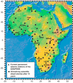
The map above shows the anticipated network of scientific observatories after year 10 of the AfricaArray project. Source: AfricaArray.
Course Overview
GEOSC 297a : THE AFRICAN CONTINENT- THE GEOLOGY AND TECTONICS OF AFRICA
(3 credits). Study of earthquakes and seismic waves to learn about
the geology and plate tectonics of the African continent.
Prerequisites: None
Earthquakes are natural phenomena that can cause immense human suffering because of intense ground shaking, and are consequently of great societal importance. Earthquakes are also important because the seismic waves that generate the ground shaking provide scientists with important information about Plate Tectonics and geology, in particular information about the structure and composition of our planet and how the insides of the planet are deforming. In this course, earthquakes in Africa and the seismic waves they generate are used to help you to learn about the geology of Africa and how the earth beneath the African continent is being deformed by Plate Tectonics.
This course was developed as part of a broad initiative called “AfricaArray,” a long-term (20 years) initiative to promote, in the full spirit of NEPAD (New Partnership for Africa’s Development), coupled training and research programs for building and maintaining a scientific workforce for Africa’s natural resource sector. The course is designed to help you understand fundamental geoscience concepts, including geologic time, plate tectonics, and the rock cycle. It also reveals the potential of Africa’s abundant natural resources, highlights their importance to sustainable economic development, and alerts us to the roles we might play as members of the scientific workforce that is needed to realize that potential.
This course is designed in four modules. Modules, in turn, are divided into weekly lessons.
Module 1: Earthquakes!
- Lesson 1: Introduction to Earthquakes
- Lesson 2: Introduction to Faulting
- Lesson 3: Introduction to Plate Tectonics
Module 2: Understanding Geology
- Lesson 4: Introduction to Map Reading and Rocks
- Lesson 5: Introduction to Minerals
- Lesson 6: More on Rocks
- Lesson 7: Volcanism
Module 3: Geologic Time
- Lesson 8: Geologic Time – Relative
- Lesson 9: Geologic Time – Absolute
Module 4: Understanding the Earth
- Lesson 10: Earth Structure
- Lesson 11: Earth Composition
- Lesson 12: Mountain Building
Offered in a “hybrid” format, each weekly lesson includes a single face-to-face class meeting (75 minutes in length), complemented by online reading assignments, self-check learning activities, and discussions. The online, hands-on learning activities are similar to the labs conducted in similar courses that are offered solely in a face-to-face environment, including the manipulation of geographic data, map reading exercises, and rock and mineral identification activities. They are designed to help you to learn skills and knowledge that you will then apply to a Course Project. While the weekly lesson activities involve working with seismic data from East Africa, the Course Project requires you, working in small groups with other students, to apply your skills and knowledge to another geographic area of the African continent. In addition to the weekly lesson activities and the Course Project, you are required to complete weekly quizzes that assess comprehension of the online reading assignments. Quizzes that come at the end of a module also assess the skills and knowledge addressed in the lesson learning activities for that module.
While not officially designated as a General Education course, The African Continent does meet Gen Ed requirements. Students who successfully complete this course may request a letter from Dr. David Bice (540 Deike Building, dbice@geosc.psu.edu) stating that fact. Dr. Bice's letter can then be given to the student's Dean's office for substitution in his/her degree audit.
What will be expected of you?
On average, most students spend eight to twelve hours per week working on course assignments. Your workload may be more or less depending on your prior experience with computing and the Web in general, and with geology in particular.
My colleagues and I have worked hard to make this the most effective and convenient educational experience possible. The Internet is still a novel learning environment, but in one sense it is no different than a traditional college class: how much and how well you learn is ultimately up to you. You will succeed if you are diligent about keeping up with the class schedule, and if you take advantage of opportunities to communicate with me, as well as with your fellow students.
Specific learning objectives associated with each lesson and project are outlined below (under "Course Objectives"). Assignment due dates are published in the Calendar (see the Calendar tab in our ANGEL space).
Course Learning Objectives
Students who excel in this course will be able to achieve the following learning objectives.
Lesson 1:
- Explain how and where earthquakes are caused
- Differentiate between an earthquake 'focus' and 'epicenter'
- Describe the different kinds of seismic waves
- Explain the basic elements of seismic wave propagation through Earth
- Pick P and S wave arrival times off a seismogram
- Describe the fundamental principles of how to locate earthquakes
- Demonstrate how to locate an earthquake
- Locate earthquakes using P and S wave arrival times
Lesson 2:
- Differentiate among the 3 major kinds of faults
- Describe the difference between a fold and a fault
- Explain why some rocks become folded while other are faulted
- Explain how a "beach ball" is made using seismic data
- Determine the kind of force that created a fault by using a "beach ball"
Lesson 3:
- Describe the basic principles of Plate Tectonic theory
- Document the major historical events in the development of the theory
- Describe the motion of plates on Earth's surface
- Relate plate motions to the forces within Earth that are making the plates move
- Identify the different kinds of plate boundaries and describe the kinds of forces that create the boundaries
Lesson 4:
- Explain what a rock is
- Explain the three basic types of rocks
- Interpret a geological map
- Locate igneous, sedimentary, and metamorphic rocks on a geological map
- Identify fault locations on a geologic map
Lesson 5:
- Define "mineral"
- Classify and group rock forming minerals according to their chemical composition
- Classify minerals by their physical properties
- Identify common rock-forming minerals
Lesson 6:
- Define the three basic types of rocks: igneous, sedimentary, and metamorphic
- Explain how, where, and when each of the rock types is formed
- Describe the physical and chemical properties of the individual rock types
- Identify the identity (group) of a given sample of rock
Lesson 7:
- Describe the three common types of volcanoes
- Explain how the volcanoes form
- Identify major volcanoes in East Africa on geologic maps
- Relate the formation of these volcanoes to plate tectonic processes
Lesson 8:
- Explain the laws and principles for correlating and determining the relative age of rock units
- Relate the development of the geological time scale to these laws and principles
- Identify the major sedimentary units in East Africa using geologic maps and determine their ages
Lesson 9:
- Distinguish between relative and absolute geological age
- Describe how absolute ages of rocks can be obtained
- Identify the absolute geological age of major rock formations in East Africa and be able to determine the age sequence of the formations.
Lesson 10:
- Identify the major layers of the earth’s interior
- Describe seismic wave refraction, and why it is important to investigating the Earth’s interior
- Sketch the earth’s seismic shadow zones
- Relate the shadow zones to our knowledge of the internal structure of the Earth
- Determine the location of the crust/mantle boundary by constructing travel-time curves
Lesson 11:
- Categorize Earth's layer based on basic composition
- Distinguish seismic velocity variations as a function of composition, temperature and depth
- Compare classification schemes of Earth's internal layers (tectonic vs. compositional)
Lesson 12:
- Describe the three types of plate boundaries
- Recognize which types of faults occur at which types of plate boundaries
- Predict whether or not volcanoes are present with only the knowledge of the type of plate boundary
- Predict the degree of metamorphism (high, medium, or low) with only the knowledge of the type of plate boundary
Required Course Materials
In order to take this course, you need to have the required course materials (see below) and an active Penn State Access Account user ID and password (used to access the on-line course resources). If you have any questions about obtaining or activating your Penn State Access Account, please contact Account Services at ITS.
Required Materials
For this course you will need to obtain the following materials directly from the vendor indicated:
