 Land Use and Land Cover Example (6.8 kb)
Notice: Links on this page lead to an on-line glossary and other sites maintained by the U.S. Geological Survey.
The Land Use and Land Cover (LULC) data files describe the vegetation, water, natural surface, and cultural features on the land surface. The United States Geological Survey (USGS) provides these data sets and associated maps as a part of its National Mapping Program. The LULC mapping program is designed so that standard topographic maps of a scale of 1:250,000 can be used for compilation and organization of the land use and land cover data. In some cases, such as Hawaii, 1:100,000 scale maps are also used.
Land Use and Land Cover Example (6.8 kb)
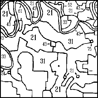
Compilation is based upon a classification scheme identified in the Appendix.
Land Use and Land Cover (LULC) data are available for most of the contiguous United States and Hawaii.
Manual interpretation of aerial photographs acquired from NASA high-altitude missions and other sources were first used to compile the land use land cover maps. Secondary sources from earlier land use maps and field surveys were also incorporated into the LULC maps as needed. At a later time, the LULC maps were digitized to create a national digital LULC database. The evolution of this process resulted in the creation of the Geographic Information Retrieval Analysis System digitization. This may be done through stereo compilation or monoscopic transfer techniques. Adjacent maps are also checked to ensure continuity. The maps are digitized and the appropriate classification codes are assigned for processing through GIRAS and checked for accuracy. All LULC data conform to the Universal Transverse Mercator (UTM) projection.
All LULC features are delineated by curved or straight lines that depict the actual boundary of an area, commonly referred to as a polygon. These polygons have a minimum size of 10 acres or 4 hectares. Each polygon represents a homogeneous element in the mapping scheme that is labeled with an integer or attribute code. The arcs and nodes of the polygon are further defined by an X,Y point or string of points that provide direction and location for the polygon. This relationship may be defined by the labeled area within the polygon or outside of it. Such positional data can be manipulated to meet a variety of user needs by reprojecting the data or re-scaling them.
The minimum area representing the man made features of the LULC polygons are 10 acres (4 hectares) that have a minimum width of 660 feet (200 meters). This minimum width precludes the existence of very narrow or long tracts of data classification. Non-urban and non-man made features may be mapped with polygons with a minimal area of 40 acres (16 hectares) that have a minimum width of 1320 feet (400 meters).
The LULC data are available in two different formats. The first format was developed as a part of the Geographic Information Retrieval and Analysis System (GIRAS). This data structure evolved as the USGS developed the LULC program in the late 70's. The other format is the Composite Theme Grid (CTG) format. This format is grid cell oriented instead of polygonal. Both formats are further defined in the Appendix under GIRAS and CTG.
The LULC data are available (at no cost) through an Internet anonymous File Transfer Protocol (FTP) account at the EDC. The data are also available (at cost of reproduction) on magnetic tape from the U.S. Geological Survey's Earth Science Information Centers.
The data on magnetic tape are ordered by 1:250,000-scale map name or by southeast latitude and longitude of the 1:250,000-scale map.
To place magnetic tape orders and to obtain additional information regarding technical details and price schedules, contact:Customer Services, EROS Data Center Earth Science Information Centers (ESICs)
Online requests for these data can be placed via the USGS Global Land Information System (GLIS) interactive query system. The GLIS system contains metadata and online samples of Earth science data. With GLIS, you may review metadata, determine product availability, and place online requests for products.
LULC data are distributed in the GIRAS or CTG formats through an anonymous FTP account or as ANSI-standard ASCII labeled or unlabeled magnetic tape. Published maps and other hard copy photo products are also available upon request.
Applications and Related Data Sets
The LULC data sets are intended to be compatible with a variety of digital data prepared by the USGS and other government agencies. For example, socioeconomic data compiled by the Bureau of Census can be compared to LULC data of the same area. LULC data can also be used in conjunction with DLG and DEM data to assist river basin planning, barrier island change analysis, environmental impact statement preparation and urban development studies.
Classification Codes
Classification Codes-first and second level categories