
Resolution of Satellite Images and Applications to Tropical Meteorology
Before the advent of high-resolution satellite images, meteorologists were mostly unaware of intricate patterns in cloud formations, such as the closed-cell stratocumulus and open-cell cumulus that formed off the coast of Peru on August 30, 2003 (see below). Intrigued? Stay tuned ... we'll divulge the science that explains these intricate cloud patterns in just a moment.
 |
| A MODIS satellite image showing open-cell cumulus and closed-cell stratocumulus clouds that formed off the coast of Peru on August 30, 2003 (from the Aqua satellite). Check out the full resolution, original image (you may need to resize your window). |
)
If you enroll in Penn State's online Certificate of Achievement in Weather Forecasting program, you would learn about atmospheric features just as intriguing as these open-cell cumulus and closed-cell stratocumulus clouds. More importantly, you will develop the skills and insights necessary to competently forecast tornadic thunderstorms as well as hurricanes and mid-latitude cyclones. Yes, our primary mission is to teach weather enthusiasts, high-school teachers, storm chasers and aspiring meteorologists to become scientifically sound, well-rounded forecasters. At the same time, we also want our students to become better weather consumers. For example, one of the goals of the certificate program is to dispel some of the popular notions that you routinely hear from television weathercasters ... like our very own Hale Stone (see his picture below).
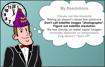 |
| After enrolling in Penn State's online certificate program, TV-weathercaster Hale Stone made a solemn New Year's resolution to be more scientific in what he says on-air. |
To his credit, Hale has come a long way. He used to refer to visible satellite images as "photographs", which, technically speaking, is incorrect. A decade ago, it was easy to distinguish a photograph (a picture printed from camera film with three emulsion layers that are sensitive to red, green and blue light) from a digital image (a screen image based on electronics and red, green and blue pixels in emitted light). Given the popularity of digital cameras these days, we admit that there is less distinction between photographs and digital images, but we draw the line when we talk about satellite images.
The major reason we don't refer to satellite images as "photographs" is that a photograph is a "snapshot" and a satellite image is a "scanshot". What does this mean? A geostationary satellite (GOES), for example, scans the earth and atmosphere with a gimbaled mirror that sweeps in an east-west direction, then in the north-south direction, and so on, and so forth. To put this scanning into more quantitative terms, a GOES satellite would require 41 seconds to scan a "box" centered over the United States with dimensions of 1864 miles by 1864 miles (3000 by 3000 kilometers).
Having kept his New Year's resolution about not calling satellite images "photographs", Hale is now ready to tackle the concept of satellite resolution. In this context, resolution refers to the minimum spacing between two objects (clouds, etc.) that allows the objects to appear as two distinct features on a satellite image. In terms of pixels, observing two distinct objects on a satellite image requires that at least one pixel lie between the objects (otherwise, they would simply blend together; in other words, the objects would not be able to be resolved).
To see what we mean, check out the interactive simulator below. As it now stands, "Cloud A" and "Cloud B" can be resolved. In plainer terms, the simulated visible satellite image on your right shows two distinct "clouds" (note that the distance between them exceeds the width of one pixel). Now we realize that the "clouds" on the simulated visible satellite image don't really look like clouds. Indeed, they're highly "pixelated". Think of the simulated visible satellite image as a zoomed-in portion of a real visible satellite image.
)
Okay, it's time to experiment with the simulator. For starters, please click on "Cloud B" and drag it as close as you can to "Cloud A". Next, please look at the simulated satellite image on your right and note that only one "cloud" can now be resolved. So, even though the breadth of each cloud on the simulator is greater than one pixel (they're approximately three pixels wide), we simply can't resolve them at this resolution because the distance between them is less than the width of one pixel. Make sense?
| An interactive simulator that will help you to better understand the concept of satellite resolution. For starters, drag "Cloud A" as close as you can to "Cloud B" and observe that you can no longer resolve two distinct clouds once the distance between the clouds becomes less than the width of one pixel. |
Before enrolling in the online certificate program, Hale Stone equated the size of the pixels with the size of an object that could be resolved on satellite imagery. As you just observed, that's simply not true. Indeed, the interactive simulator should convince you that the size of the pixels (i.e., the resolution of the image) and the size of resolvable objects on or near the earth's surface are not the same (keep in mind that each cloud was approximately three pixels wide). More importantly, you should now have a sense that satellite images with increasingly high resolution will allow you to see greater details in cloud patterns.
To see how increasing the satellite resolution (reducing the size of the pixels) allows you to see greater detail on satellite images, please explore this interactive exercise. Just place your cursor on the red triangle and slide it right or left to change the resolution of the image. At the same time, note how easily (or how difficult) it is to observe distinct cloud elements.
Clearly, resolving open-cell cumulus and closed-cell stratocumulus clouds over the ocean requires satellite images with high resolution (the resolution of the satellite image at the top of this page is one kilometer, but you can access MODIS images with resolution as high as 250 meters). Now that you know that we can resolve such intricate cloud patterns on satellite images, let's delve deeper into the science underlying open-cell cumulus and closed-cell stratocumulus.
As we discuss in Meteo 241: Fundamentals of Tropical Forecasting, there is a chain of high-pressure systems that girdles the globe near 30 degrees latitude (North and South). To see what we mean, check out the long-term average for mean sea-level pressure from June through August, which shows the belt of subtropical highs in all their glory.
)
On the western maritime margins of the subtropical highs, relatively warm, humid and increasingly unstable air flows poleward, setting the stage for convection. On high-resolution satellite imagery, convection sometimes appears as cloud patterns that roughly resemble hexagonal, ring-like patches. The Meteosat image image below captured open-cell convection over the Atlantic Ocean on the western flank of the resident subtropical high. Note that the centers of individual patches are "open" and surrounded by a ring of cumulus congestus and cumulonimbus. Clearly, air sinks in the center of each cell and rises around the edges, creating a lacy, hollow-looking array.
)
Typically, an individual ring in the array of open-cell convection has a diameter that ranges from 20 to 200 kilometers. Although the full scientific explanation of open-cell convection is beyond the scope of this discussion, we wanted to give you a heads-up about the different kinds of convection you can sometimes see over the oceans on satellite imagery. For the record, open-cell convection can also occur over mid-latitude oceans (just so you don't have the impression that open-cell convection is restricted to the subtropical oceans).
)
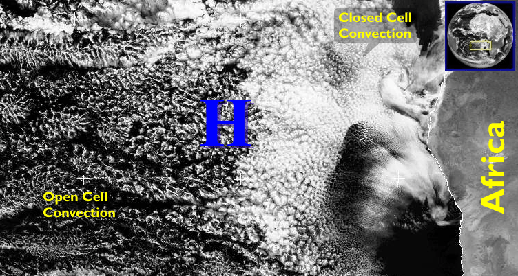 |
| A high-resolution satellite image from Meteosat on August 17, 2004, over the southern Atlantic Ocean (to the west of Africa) captured an array of open-celled (left) and closed-celled (right) convection (large, unannotated image; drag window size to fit your screen). |
)
Again, such intricate structures in cumulus clouds were unknown before the advent of weather satellites because the cell-like patterns were simply too small to be resolved by the fragmented observational network. And the closely packed mesh of clouds was just too large to be recognized from aircraft.
There's more to observe on the Meteosat visible image (above) -- note the closed-cell convection just off the southwest coast of Africa. Such an array consists of individual pancakes of stratocumulus that tend to be smaller in horizontal span than their open-cell counterparts (compare the two with this extreme close-up). Moreover, there's a pretty good difference in the modest vertical development of the closed-cell elements compared to the towering cumulus congestus and cumulonimbus that sometimes ring the open cells. We most often observe closed-cell convection on the eastern flanks of the subtropical highs, where the concomitant subsidence inversions occur at relatively low altitudes and the boundary layer is stabilized by cool ocean water (from upwelling). The bottom line here is that air rises in the center of closed-cell convection and sinks around the edges.
)
Feeling confident about what you just learned? Then, by all means, go right ahead and test your knowledge by taking the quiz below.
Test Your Knowledge
You are given a visible satellite image from GOES-10 over the Pacific Ocean. Simply pull down the menu and select the point that corresponds to each cloud type.
If you want to further explore the concept of satellite resolution, check out the various resolutions of MODIS images of Hurricane Katrina on August 28, 2005. By increasing the resolution, you should be able to better observe the small details associated with the mesovortices in the eye of Katrina (the swirls in the stratus and stratocumulus clouds inside Katrina's eye). We talk more about mesovortices in Meteo 241 as well as lots of other interesting topics in the other three online courses that comprise Penn State's popular program that confers a Certificate of Achievement in Weather Forecasting.
©1999-2006 The Pennsylvania State University. All rights reserved.