Quick Guide to the Stages of Tropical Cyclones
Tropical Disturbance
A tropical disturbance is a cluster of showers and thunderstorms that flares up over the tropics. It is typically about 100 to 300 miles in diameter and generally moves westward. Tropical disturbances last for more than 24 hours, so there's a clear distinction between mundane diurnal convection and tropical disturbances. Lacking a closed circulation of winds, tropical disturbances do not qualify as tropical cyclones. To see a series of satellite images detailing the evolution from tropical depression to Hurricane Isabel, see the animation at the bottom of this page.
Tropical Depression
Over warm, tropical seas, tropical disturbances sometimes develop a conspicuously cyclonic wind circulation that's closed. If the maximum sustained winds are less than 34 knots (39 miles an hour), the low-pressure system qualifies as a tropical depression. Tropical depressions typically have a diameter that's on par with tropical disturbances. In order to maintain records on tropical depressions, meteorologists sometimes use a number system. For example, "Tropical Depression Four" in the Atlantic basin indicates that the depression is the fourth one to develop during the given hurricane season. Even though tropical depressions do not receive a formal name, they still qualify as a tropical cyclone. To see a series of satellite images detailing the evolution from tropical depression to Hurricane Isabel, see the animation at the bottom of this page. By the way, some tropical depressions never reach the next stage in the development of tropical cyclones. Click here for a discussion of such a tropical depression.
Tropical Storm
Once the maximum sustained winds of a developing tropical cyclone reach 34 knots, the low-pressure system is typically called a "tropical storm" and assigned a formal name. The tropical cyclone maintains its tropical-storm status as long as its maximum sustained winds are less than 64 knots.
Hurricane/Typhoon/Severe Cyclonic Storm/Severe Tropical Cyclone
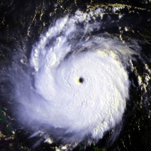 |
| Hurricane Andrew as a Category 5 hurricane off the coast of Florida, August 23, 1992. Click here for a high-resolution image. |
)
Although these storms vary in size, a typical hurricane has a diameter on the order of 650 kilometers. On average, hurricane-force winds extend about 100 kilometers from the storm's center, but gale-force winds (sustained winds greater than 28 knots) may extend as much as 500 kilometers from the storm's center.
Case Study: Hurricane Isabel
You can follow the evolution of Hurricane Isabel (early September, 2003) through the various stages of development by exploring this flash animation of satellite images from Meteosat (the European geostationary satellite).