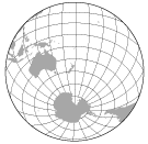
(B)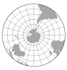
| (A)
(B) | |
| Figure 4-1. The northern hemisphere (A) and the southern hemisphere (B) on the Azimuthal Equidistant projection |
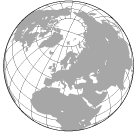
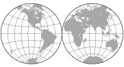
(A)
(B) | |
| Figure 4-2. The western hemisphere (A) and the eastern hemisphere (B) on the Lambert Azimuthal Equal-Area projection |
(A)
(B) | |
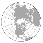
| Figure 4-3. The land hemisphere (A) and the water hemisphere (B) on the Lambert Azimuthal Equal-Area projection, centered on 47°13' N, 1°32' W, and 47°13'S, 178°28' E, respectively. (After Boggs, 1945, p. 345) |
(A)
(B) | |
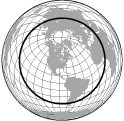
| Figure 4-4. The Orthographic projection centered on East Lansing, Michigan (A), and centered on the Baltic countries (B). The Orthographic projection simulates what we see when we center a globe on these points. |
(A)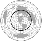
(B) | |
| Figure 4-5. Two planar projections, the Azimuthal Equidistant (A) and the Lambert Azimuthal Equal-Area (B) of the whole world centered on East Lansing, Michigan. The inner hemisphere surrounding the center point is wel represented, but there is extreme distortion beyond the hemisphere |
 | |
| Figure 4-6. The world on two Nicolosi Globular hemisphere projections |
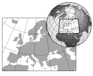 | |
| Figure 4-7. The use of Orthographic projection as a locator map. The area of the rectangular regional map is delineated on the Orthographic inset. The shadowing helps to give us the impression that we are looking at a globe |