Africa Through Geological Time

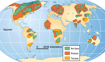
World map showing cratons.
Source: American Museum of Natural History
Let's get back to Africa! Where has Africa been for the past 4.55 billion years? It hasn't looked the same as it does today; because of plate tectonics, it has moved around the globe and changed in size and shape.
These maps are our best reconstructions of where the continental masses were located at various times in Earth's past. You probably notice lots of words that you don't recognize. Some of these, like Laurentia, are place names, the names we have given to earlier configurations of the continents. Others refer to the time periods defined by geologiststhe geological time scale that we reviewed earlier in this lesson.
Africa itself is made up of several pieces of ancient continent--called cratons--that became stuck together many millions of years ago How ancient are they? Some parts of the continent are over 3 billion years old, so they are from the preCambrian era! These ancient cratons are important today because they were the sites for volcanic activity that produced diamond deposits at the Earth's surface. The map to the right/above shows the locations of all ancient rocks around the world (the unlabeled areas are simply covered with younger rocks that won't have any diamonds).
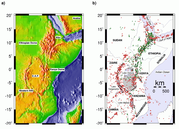
In addition to the convergent activities that joined the various pieces of craton together, Africa has experienced several periods of rifting (divergence) as well. Today, the best example of a continental rift is located in Africa (see the image below). The rift began with a major outpouring of flood basalts in central Ethiopia about 30 million years ago, in the Oligocene period. Since then, volcanism and rifting have marked the future site where the continent will split.

Continental rift in Africa. Source: Courtesy of Randy Keller, UTEP
Note: Please click on the image to see a larger version.