Global Climate Chages - Comparing Egyptian Data with European Data
It sounds like we are still only talking about the Nile, and not about climate or climate change. The remarkable truth is that we use today the ancient flood records of the Nile to tell us about the regional climate and how it has changed. Remember, the Nile flood tells us how much rain has fallen in Ethiopia, while the Nile flow (non-flood stage) tells us how much rain has fallen in central Africa. Thus we can use the levels of water in the Nile to tell us where and how much it is raining in a large region of the African continent.
Even more remarkable than that—we will compare the results from the Nile basin to records from Europe, where written record-keeping began with the Vikings. Thus, we can see how global climate variations have occurred for over one thousand years. You should not be surprised that there are correlations, because you remember that all of the planet's air masses operate in synch with one another. Let's see what we learn.
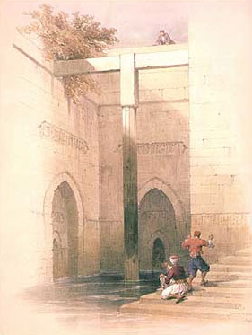
Painting of the Nilometer on Roda (Rawda) Island. Source: http://touregypt.net/featurestories/nilometerroda.htm
In 715 AD the Roda Nilometer (Nile-o-meter, get it?) was built on the island of Roda (Rawda) in Cairo to record the height of the flood. It operated almost continuously through the 20th century. The Nilometer is an enclosed staircase that enables one to descend toward the river. The height of the flood was noted on the wall, and measured from the top of the structure down to the water.
So what do we learn about the Nile floods from the Roda Nilometer?
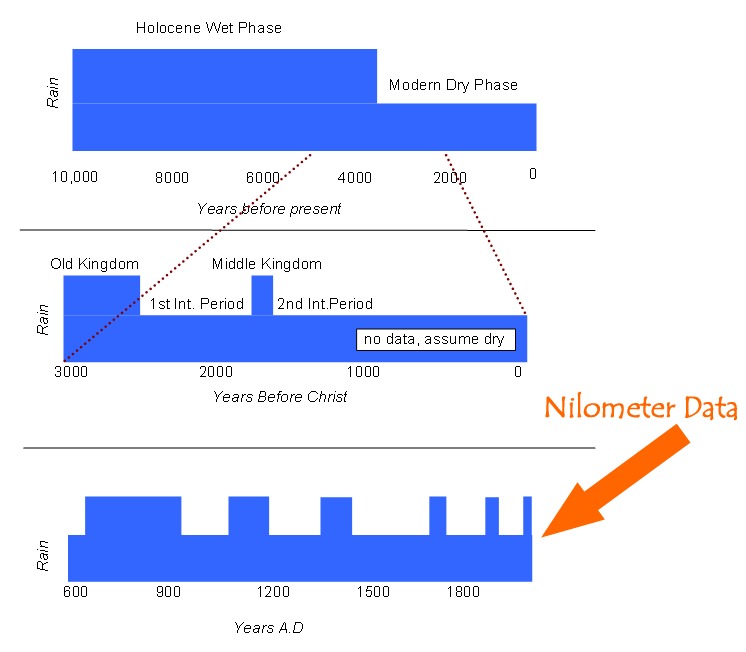
Schematic representation of rainfall in the lower Nile valley over the past 10,000 years. Time periods of relatively high rainfall (and Nile flow) are indicated by a thick blue bar, while correspondingly dryer periods are indicated by the shorter blue bar. Notice how the frequency and duration of wet episodes has decreased consistently since the early settlement of the Nile delta. Source: The personal collection of Dr. Tanya Furman.
Note: Please click on the image to see a larger version.
Flood Records of the Nile
| 640-930 AD | A time period of ample floods, but levels show a gradual decline in Ethiopian rainfall over the final 200 years. In Europe the climate was warm, and the Vikings first began to settle Iceland and Greenland. |
| 931-1090 AD | Nile failures (years when the flood did not arrive at all in Cairo) were common during this period. The maxima were constant, but the minima were low. From between 1052 and 1090 there were a total of 28 low floods, often occurring in successive years and thus resulting in severe food shortages. Documents from these times record starvation, disease, and cannibalism among the people (the population dropped from 2.4 million to 1.5 million). The economy suffered from terrible inflation, and a decline of the arts. |
| 1090-1195 AD | In the Nile Valley this period was one of normal and good floods. In Europe, this century marks an episode of warming that led to the expansion of the Viking network, including their development of Greenland as a farming community. |
| 1196-1350 AD | These decades mark a period of low Nile flood levels. |
| 1351-1467 AD | This time period was one of high Nile floods and flows, with people in the Nile Valley and Delta living in great fear of extreme flooding. During this time the Saharan and Sahelian empires became strong, including the kingdoms of Mali, Songhay, Kanem and Bornu. Thus in immediately sub-Saharan Africa the rains were much heavier than today and centralized societies with artisans and strong governments developed. |
| 1468-1510 AD | The end of the 15th century was a time of low Nile floods. We see this lack of rainfall manifest in the political and social history of Sahelian Africa, where the major empires disintegrated and the international slave trade strengthened. |
| 1511-1630 AD | We have little data on the flood levels of the Nile during this time, because Egypt was invaded by the Ottoman Turks and record-keeping was not carried forward. This invasion itself indicates a period of low political strength and thus likely low Nile floods. It appears that the rains stayed strong in central Africa, despite weakening over Ethiopia, because the Songhay empire regrouped, and other Sahelian societies returned to strength also. |
| 1631-1840 AD | This era was mainly a period of low Nile flows (except 1721-1780). There were frequent droughts in the Sahel and nomadism became the dominant way of life as centralized societies fell apart and the slave trade flourished. In contrast to the previous period, the Ethiopian rains were unusually high but the equatorial rains failed, so drought was bad in the sub-Saharan areas now known as Senegal, Gambia, Mauritania, Mali, Burkina Faso, Ghana, Nigeria, and Chad (half the population of Tombouctou died), but the Nile Valley itself was well-watered. This period coincides with the Little Ice Age of Europe ~1600-1850. During this time the Alpine glaciers advanced dramatically, Iceland was surrounded by pack ice 6 months each year (leading to massive starvation as crops could not be planted nor fish caught), the Thames River froze every winter, and North Africa was dry. |
| Modern Africa | You have already researched the changes in Nile flood levels from 1913 to 1959 (remember the Egypt-Sudan Water Treaty), so you know that the Nile flood level in the first half of the 20th century was adequate for farming and for meeting the needs of a growing population. Unfortunately, the Ethiopian rains declined in the 1960s through the 1980s, greatly reducing the level of the Nile flood. There was an increased Nile flow in the 1960s dominated by equatorial rainfall that offset the loss of the Ethiopian rains, but only because the waters were trapped by the Aswan Dam. |
The image below shows the location of several significant centralized agricultural and artistic societies that occupied that Sahelian region when the climate was more favorable than it is today.
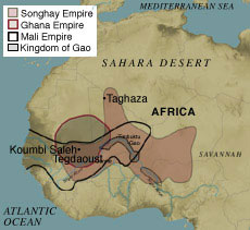
Ancient kingdoms of the Sahel. Source: http://www.metmuseum.org/toah/hd/wsem/hd_wsem.htm
These images show the beautiful and complex structures built at the height of power in the Sahelian empires. The buildings are made of mud, and many have been repaired or largely rebuilt in recent decades.
What
do YOU think? Climates of Africa, Part II
Go to the Lesson 08 Discussion Forum (This discussion forum can be accessed at any time by clicking on the Communicate tab in ANGEL and then looking in the Discussion Forums box.) and post a response to the following question: How do you think the alternating periods of flooding and droughts biases the archaeological record of ancient Egyptian civilizations?