What is a Desert?
What is a desert, anyway? There are two main categories of definition, and they don't always agree, which makes for a political nightmare.
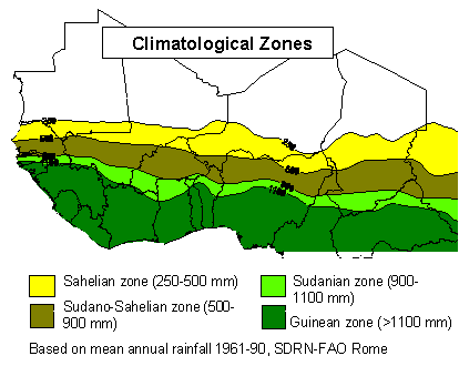
Rainfall Zones. Source: Food And Agriculture Organization Of The United Nations
The image above shows the climatological definition of desert: it is an area where the annual rainfall is less than 250 mm. How little is that? Remember that one inch = 2.54 centimeters (and each cm has 10 mm), and it is quickly clear that the desert receives just under 10 inches of rain each year. In State College, PA we typically receive 38.5 inches of rain (including snow as converted to liquid precipitation). In Lagos, Nigeria, they receive close to 75 inches of rain annually — most of it within a 5-month period in the summer.
The second definition of desert is based on plant life, which is easier to observe but also less reliable as a working term. Why? Animals, including principally the livestock of semi-nomadic peoples, eat vegetation. In a dry year, when the vegetation may be more sparse than normal, the amount eaten by livestock may devastate temporarily the vegetative ground cover. As a result, it looks from satellite imagery that the desert has grown. Indeed, the area of land covered by desert landforms may have increased, but the region receiving low rainfall has likely not changed at all.
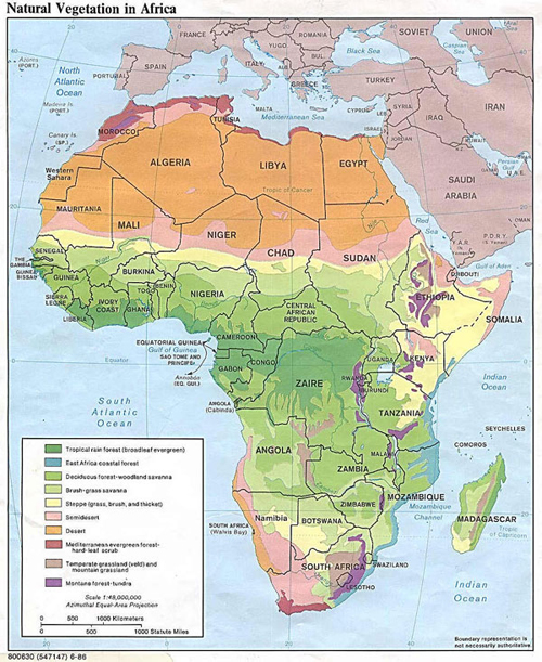
Natural vegetation in Africa.
Dark green = tropical rain forest,
Blue = East Africa coastal forest,
Medium green = deciduous forest-woodland savanna,
Light green = brush-grass savanna,
Yellow = steppe,
Pink = semidesert,
Orange = desert,
Red = Mediterranean evergreen forest,
Brown = temperate grassland, and
Purple = montane forest-tundra.
Source: African Conservation Foundation - http://www.africanconservation.org/vegetationmap.html
This mismatch between definitions caused political havoc in the 1970s when prolonged drought resulted in an apparently huge increase in the size of the Sahara. It was then wrongly inferred that the rainfall patterns had changed! Nonetheless, changes in the apparent size of the Sahara are monitored very closely because the environment is marginal for human habitation at best.
Estimates of accumulated precipitation for the African continent are prepared at the Climate Prediction Center for the United States Agency for International Development (USAID) as a part of the Famine Early Warning System Network (FEWS NET). These estimates are archived and made available by the United States Geological Survey (USGS) from the Earth Resources Observation Systems (EROS) Data Center to assist in drought monitoring efforts for sub-Saharan Africa.