Desertification
We mentioned the notion of desertification at the beginning of the lesson, and it is time to return to that topic. When we say land has become desert, what does that mean?
The following image (taken from the southwestern US) shows dramatically the working definition of desertification: the generation of new uncultivable land. Whether desertification occurs through human activity, such as overgrazing, or through natural processes, such as climate change, it represents a major threat to the people who live in the marginal Sahelian zone.
It is not simply the process of an area becoming dry, and it is not simply caused by drought. In fact, desertification is usually defined as a process that happens to land that is already normally arid (dry) or semi-arid. The most important factor in documenting desertification is a decline in the biological productivity of the land, that is, the amount of vegetation that grows (either naturally or planted by man), and the animal life supported by the plants. Desertification is often portrayed as a moving line, with barren sand dunes pushing forward into productive land. In reality, desertification is usually a patchy development, spreading outward from pockets of land where the vegetation has been harmed or destroyed, so that sandy dry soil begins to drift and vegetation is unable to reestablish itself.

Defining desertification - generation of new uncultivable land. Source: http://www.gse.mq.edu.au/units/gse813/CSIRO/environ/desertification.htm

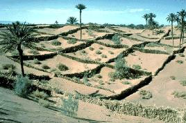
Desertification barrier - palm and tamarisk trees, Morocco. Source: Premaphotos Wildlife
This image shows one way in which farmers in southern Morocco have tried to slow the process of desertification: they plant palm and tamarisk trees in an attempt to stabilize the soil (which is, after all, sand) and prevent the dunes from overtaking the agricultural land.
Sometimes desertification begins in the most unexpected ways. In western Africa, water wells are often the nuclei for desertification, because they attract livestock which overgraze the land nearby.
In this case, the point of initial desertification is a paved highway that was built recently to connect Nouakchott, the national capital of Mauritania, with the regional capital Rosso. Building this road was a necessary and beneficial action. It makes communication, trade and travel between these cities much easier, and thus serves as an agent of development in much of the country. However, it is also a nucleus for desertification. In addition to vehicle travel on the road itself, this highway has encouraged building of small settlements, as well as human and animal travel along its corridor. All of these activities consume vegetation for grazing, fuel, and building material. The vegetative cover has become disturbed, some of the sandy soil began to drift, and the process of desertification is underway.

Highway settlements, Mauritania
Source: USGS
The images below show southern Mauritania and northern Senegal, in West Africa. The Senegal River, labeled in the 1972 image, flows westward across the landscape and interrupts the dry terrain to north and south. The regional capital Rosso is on the north bank of the river, and the town of Richard Toll ("Richard's Field" in the Wolof language) is on the south bank. Mauritania's National Highway 2, seen at ground level in the previous picture and shown in these images as a red line, connects Rosso to the national capital Nouakchott.
Both images are from the dry season which follows the wet summer growing season. Note how apparent the highway corridor is in the 1990 picture. The 1972 image has more bright, exposed sandy soil, with a hint of healthy vegetation (faintly pink tones) in the northwest, whereas the dark vegetation in 1990 shows dry plants that grew during the wet season. The prevailing winds have, over hundreds of years, caused longitudinal dunes to form across the whole area, since the soil is mostly sandy. In the 1990 image you can see many bright red fields (they are red because this image is falsely colored to highlight certain features). Most of them are sugar cane and rice, and virtually all of them are irrigated. The amount of irrigated land increased greatly between 1972 and 1990, and new irrigation canals are visible.
What
do YOU think? Stop desertification! ... or can we?
Go to the Lesson 09 Discussion Forum (you can easily find that discussion forum by looking under the Communicate tab in ANGEL) and post a response to the following question: What steps can we take to stop desertification? With the growth of human populations and the need for resources, should we even worry about desertification? Explain your thoughts to both questions.