What Is Geography?
People use the word "geography" all the time. And while it has many uses and meanings, most people would be at a loss to define what "geography" is. We are going to examine the definition and scope of geography but before we do, I want to see how you might define "geography".
Geography Defined
Let us take the word "geography" apart. The word geography can be broken into the two basic elements of "GEO" and "GRAPHY." Geo comes from the Greek word for Earth (the word Gaea also meaning earth derives from the Greek as well). The "ography" part comes from the Greek word graphein which is literally to write about something. The word "graph" derives from the same basis.
Thus GEO + GRAPHY literally means "to write about the Earth." We have commonly come to understand that the translation might also be taken as to describe and map the earth. The American Heritage dictionary defines geography as "the study of the earth and its features, inhabitants, and phenomena." I agree with the dictionary, but I like to tell my students that geography really is the study of how the world works in terms of the physical and human processes that occur everyday.
So for me, Geography is really about how the world works. That is pretty good knowledge for a geospatial analysts to possess.
Breaking it Down
Understanding how the world works is a pretty tall order, so let us break down the study of geography into some manageable parts. At the most basic level, think of geography as a coin with two sides.
HEADS: On one side we have Physical Geography or the study of the spatial distribution and of naturally occurring phenomena.
TAILS: On the other side we have Human Geography or the study of the spatial distribution and attributes of human induced/engineered phenomena.
Physical geography looks at the natural processes that make the surface of the earth the way it is. Physical geography includes the three major sub-disciplines of Geomorphology, Meteorology, and Climatology.
Geomorphology is the study of landforms and landform processes. Geomorphologists want to know:
- What are the different landforms
- Where are the different landforms
- Why are they where they are
- How do they form
- What will happen to them over time
Meteorology is the study of atmospheric weather processes. Meteorologists want to understand:
- What are the different atmospheric processes that create our weather
- Where do these weather phenomena occur
- How and why does the planetary weather system work the way it does
- What will happen with the weather in the future so they can forecast the weather
Climatology is the study of climate which is basically the long term pattern of temperature and precipitation. Climatology like meteorology is a branch of the inter-disciplinary field of Atmospheric Science. Climatologists seek to understand:
- What are the different climate types found on earth
- What processes cause these different climate types to occur in specific places (i.e. why are there different climate types)
- Where do these climates occur
- How and why do climates change over time
- What will happen to the earth's climate in the future so they can forecast the effects of climate change
Human geography looks at the human activities that make the surface of the earth the way it is. Human geography includes numerous sub-disciplines some of which are:
- Population geography
- Cultural geography
- Economic geography
- Political geography
- And many others
Human geography is essentially synthesizing a spatial perspective with one of the topical disciplines to come up with new knowledge and a new perspective to understand how the world works.
Geographic Techniques
The world is fortunate the geographers throughout the ages have developed a set of spatial tools to help us understand how the world works. These tools are often referred to as the geographic techniques and they include the sub-disciplines of:
- Cartography: The art and science of making maps and the oldest of the geographic techniques.
- Remote Sensing: The art and science of obtaining information about the earth by study from afar.
- Geographic Information Systems: A GIS is a computer based system that collects, stores, analyzes, and displays spatial information to solve problems.
- Global Positioning Systems: The use of a system of satellites, ground stations, and receivers to obtain precise locational information of phenomena on the earth.
Geospatial intelligence relies heavily on the geographic techniques (collectively known as Geographic Information Science and Techniques (GIS&T) or GIScience) for the collection, analysis, and communication of results. Your other coursework will involve very detailed explorations and applications of the geographic techniques.
The Relationship of Physical Geography to Human Geography
In my Introduction to Geography classes (usually for freshmen and sophomores) I like to stress the point that physical and human geography are completely separate disciplines and that there can be NO mixing between the two. In fact I make a big deal that they must write this down and put stars by it in their notes as this important point will most certainly be on the test. I then stop and let them think about this statement as they dutifully write it down.
Now you might be thinking that my contention that physical and human geography are completely separate and can never be mixed seems nonsensical—and you would be correct. Eventually a few of the students start to grin and perhaps a bold one might challenge me (not very often though).
I then get to point out to the students the fallacy of such a contention and make the point that physical and human geography, like the sides of a coin, are absolutely inseparable. We know that physical systems can have enormous impacts on human systems (ask the survivors of Hurricane Katrina). We also know that human impacts on the environment have been great as humans have always modified the surface of the planet to scratch out a living or to build great civilizations (western Europe has a climax vegetation of forest—consider the landscape there now—forests are rare, protected, and highly valued).
I think that the geographic sub-discipline of Environmental Geography occupies the space in the center of the coin gluing human and physical geography together. A problem in many modern geography programs is that students specialize in either human or physical geography with inadequate knowledge of the other side of the coin. The even greater problem is for students who specialize in the geographic techniques (I affectionately call them "Techno-Geeks") and lack the necessary background in human and physical geography.
Now that you have a basic understanding of the definition and scope of geography, study the Wikipedia article on Geography. Compare and contrast what I have said with the article. Are there any significant differences, and if so, why?
http://en.wikipedia.org/wiki/GeographyThe Four Traditions of Geography
There are some other ways to conceptualize the field of geography. Parkinson suggested that geography has four traditions: The Earth Science Tradition, Culture-Environment Tradition, Locational Tradition, and Area Analysis Tradition. Geographic techniques support of these traditions. The chart below shows how selected sub-disciplines fit within these four traditions.

Figure 1: The Four Traditions of Geography.
SOURCE: Corson, 2007.
All of the sub-disciplines with the exception of the Regional Approach are topical approaches. The regional approach breaks the earth down into areas that share certain uniform cultural and physical characteristics. Regional geographers then study the human and physical geography of that particular region. We typically break the world into the cultural regions of: North America, South America, Europe, Russia and the Slavic World, the Middle East and North Africa, Sub-Saharan Africa, South Asia, East Asia, Southeast Asia, and Australia and Oceania.
Geographic Systems Theory
Yet another approach to understanding the scope of geography is Geographic Systems Theory. A system is a series of components such that when you add energy to it the components work together to produce an output. Take for example your stereo system. Your system probably includes a tuner, CD player, amplifier, and speakers. You must plug it in (add energy to it) to get an output which is your sweet music. Open systems exchange both energy and matter with the outside universe. Closed systems exchange only energy.
The earth is a system. Is it a closed system or open system? The answer is the earth is a closed system in that it exchanges energy with the universe but it does not exchange any significant amount of matter (space junk and meteorites are insignificant—if earth is destroyed by an asteroid I will admit I was wrong).
According to Geographic Systems Theory the earth has two major sub-subsystems which are the Physical Subsystem and the Human Subsystem. The Physical Subsystem has four major component subsystems of the Atmosphere, Hydrosphere, Lithosphere, and Biosphere. The Human Subsystem has the three major components of Beliefs, Institutions, and Technologies.
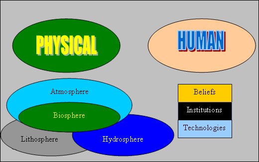
Figure 2: The two major sub-subsystems of the earth.
SOURCE: Corson, 2007.
The atmosphere is the gaseous envelope that surrounds the earth and sustains air breathing animals. The lithosphere is the solid rock and soil that comprises the outer solid layer of the planet. The hydrosphere includes all the liquid and solid water (water vapor is in the atmosphere). These three spheres are "abiotic" in that they are non-living. The final sphere is the biosphere containing all life. The biosphere relies on the other three abiotic spheres to function for it to sustain life.
A critical part of systems theory is understanding that if one system is significantly degraded then the system function as a whole degrades. And if one system fails, then the whole system fails. If you consider that Planet Earth is the spaceship for the human race, and that we rely on all of its systems to function properly, you start to contemplate why we do not take better care of it. It is the only spacecraft we have and there are no lifeboats.
Geography as Synthesis
Geography is a synthesizing discipline in that geographers take topical subjects and analyze them through the spatial filter thus seeing the world in new ways. This synthesis is very exciting and liberating in that geographers have the freedom to explore many different subjects and apply topical, chronological, and spatial approaches while integrating both the human and physical world. No other academic discipline takes such a holistic approach and that makes geography special.
Why I Love Geography
I have to admit I love geography and being a geographer. Now sometimes I get frustrated by geographically illiterate people who thinking geography is nothing more than knowing place names and being very good a the geography part of Trivial Pursuit. One person was incredulous when I told them I have a doctorate in geography. The person said, "Ten years of college to be a geography professor! You must know where everything thing is at. Do you know how to get to the closest liquor store?!" That fellow was ignorant of true scope of geography. You now have an inkling having studied the nature of the discipline just how rich is the body of geographic knowledge and thought. To be a geographer is literally to try and understand how the world works. I love this business because it gives me the freedom to synthesize my interest in political processes, the military, and the environment to come up with research projects such as "The Military and the Environment in the Post Cold War Era." What other discipline will let you have that freedom? I also love geography because geographic knowledge is essential in my role as a Soldier. Knowledge of regional weather, climate, terrain, culture, politics, etc has been critical in my military adventures. Likewise my knowledge of geography has allowed me to take on missions outside my military specialty. I was asked to go to Kosovo because of my knowledge of the region and knowledge of political geography. I was asked to negotiate and write the US-Kuwait bi-lateral agreement on the Coalition Border Crossing between Kuwait and Iraq due to my civilian acquired skills as a political geographer. So I admit it—I love geography as a subject, I love being a geographer, and I love sharing geography by being a teacher.
The Necessity for Geographic Literacy
The world is getting smaller, more crowded, and more integrated as the population expands, resources diminish, and globalization brings us all closer together. The US is a "hyper-power" with unprecedented influence around the globe. For the citizens of such a country that is also a democracy comes a duty to be geographically literate—to understand how this planet works in terms of its physical and human geographies. Geographically illiterate citizens will at best be ignorant of what their government is doing globally, and at worst support their government in making bad decisions that are detrimental to national, regional, and global stability and well being.
Globalization means that America will interact with its global neighbors through combinations of cooperation, competition, and (unfortunately) occasional conflicts. Thus it is essential that American citizens be geographically literate so that they may hopefully cooperate most of the time, compete some of the time, and occasionally engage in conflict. Viewed this way, geographic illiteracy might be seen as a threat to national security. Of course this is true for citizens of other nations as well, however national rankings of geography literacy show that our neighbors abroad understand the importance of geographic knowledge and do not suffer our illiteracy.
Geographic literacy for intelligence professionals (especially analysts and managers) is especially important. The geospatial intelligence professional must be geographically literate to fully leverage the power of the geographic techniques. To reiterate the fundamental and rationale for this course:
A geographically illiterate analyst or manager is likely to produce flawed analysis and poor decisions. In the national security arena this could result in disastrous policy decisions. In the disaster relief/international humanitarian aid arena this might result in wasted resources and lost lives.
If you get the feeling I am passionate about this topic—you are right. I am on a mission to stamp out geographic illiteracy one classroom full of ignorant people at time. That is a major motivation for me to teach this course to current and future geospatial intelligence professionals.
I now want you to read your second reading assignment by the noted geographer Dr. Harm de Blij. Dr. de Blij is was an especially well known public figure because he served as the resident geographer of ABC's Good Morning America for several seasons. His book on Why Geography Matters is worth your time to read. For our purposes you will only read chapter one, but if it piques your interest I encourage you to read the whole book. Chapter one is on eReserve at the Penn State Library. Click on the link below to access it.
Reading
Return to ANGEL and click on the Resources tab. Look in the Penn State Library Tools section of the page and click on the link to the Library Reserves. You should see a page listing:
"Why geography matters" (sic)
De Blij, Harm J.
Use the "Click Here for Full-text" link to read or download the pdf file.
Click the following link to access a PowerPoint Presentation with a review of the Definition, Nature, and Scope of Geography.