Where Does the Water Go?
For several thousand years the Egyptians developed as a people and as a civilization on the basis of the annual flooding of the Nile. During the early history of Egypt there was generally ample water for human use--Nile floods were generally higher than today and the population was lower. By the beginning of the 20th century, however, during the period of British rule, the growth in population coupled with an increase in both agriculture and industry led people to consider basin-wide water management a priority. The need to control the annual flood was obvious: industrial development depended on the Nile, but losing one's livelihood to flood waters on a regular basis was not economically viable.
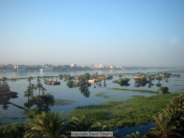
The Nile in Flood (Luxor). Source: Photo by David Titherly.
The Old Aswan Dam
In 1899 construction began on the first Aswan Dam, now known as the Old Aswan Dam. Most of Egypt is quite flat, and there are no great river valleys to dam as has been done throughout the world. The few rocky areas ("the cataracts") provide the only places to anchor a dam, and they are all located in southern Egypt far from the delta and the population centers. The Old Aswan Dam was built at the first cataract, at the city of Aswan near the Egyptian-Sudanese border. During this time the area that became Egypt and the Sudan was controlled by the British, so there really was no border about which to be concerned.
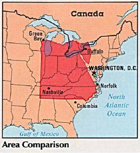
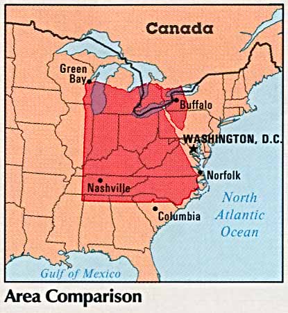
Egypt (shown here as an overlay on the U.S.) is huge. Imagine trying to manage the water resources for this country AND the Sudan! Source: http://www.lib.utexas.edu/maps/atlas_middle_east/egypt_area.jpg
The Old Aswan Dam was upgraded twice, first from 1907-1912 and then again from 1929-1934, as it struggled to meet the needs of growing Egyptian cities in terms of water storage (primarily for agriculture) and flood control. By 1952 it was clear that a larger structure would be needed, and planning began for the High Aswan Dam.
The High Dam
In 1952, the interim Revolutionary Council government of Egypt decided to build a High Dam at Aswan, about four miles upstream of the old dam. The dam was needed for three main reasons:
- To generate hydroelectric power
- To protect residents of Cairo from the flood, and
- To expand the amount of arable land through irrigation
In addition, the project was seen as a symbol of Egypt's control of the Nile after the 1952 revolution. The Aswan dam would be the biggest, most dramatic dam in the world, a gigantic confirmation of the efforts of a newly independent nation.
In 1954, Egypt requested loans from the World Bank to help pay for the cost of the dam (which eventually added up to US$1 billion). Initially, the United States agreed to loan Egypt money but then withdrew their offer, perhaps because of the growing Egyptian and Israeli conflict. The USSR offered to help and Egypt accepted. The Soviet Union's support was not unconditional, however. Along with the money, they also sent military advisers and other workers to help enhance Egyptian-Soviet ties and relations.
Damming the Nile by building the Aswan High Dam would produce a huge reservoir of water extending south from the first cataract. The reservoir was named for the former president of Egypt, Gamal Abdel Nasser, who died in 1970. The lake was designed to hold 169 BCM of water - just over 2 years worth of pre-1959 flood. Some 17% of the lake - when full - is in Sudan. For the first time, a multinational agreement was needed to share the waters of the Nile. In 1959 - just prior to the start of construction - the Egyptians and the Sudanese signed a water treaty setting out their new arrangement. Construction was started in 1960 and fully finished 10 years later.
The Aswan Dam really is an engineering marvel. The embankment is 111 meters high, and nearly 1,000 meters wide. Lake Nasser is 480 km long and up to 16 km wide. The power station has a yearly output capacity of 2.1 gigawatts, but the full capacity cannot be exploited when Lake Nasser is not at full capacity.