Problems with the Aswan Dam
The 1959 Water Agreement divided up the average annual Nile waters as shown below:
| Egypt | 55.5 BCM |
| Sudan | 18.5 BCM |
| Evaporation | 10.0 BCM |
| Total | 84.0 BCM (average flow 1912-1959) |
Naturally, when the river's flow was below the long-term average, sharing according to those specifications was impossible. The Egyptians, who are more heavily industrialized than the Sudanese, claimed that their water needs should take priority, leading to regional tensions that persist to this day. Oddly enough, the Ethiopians, in whose country the Blue Nile begins, were left out of the 1959 agreement entirely.
The Nile River and the Aswan High Dam are Egypt's lifelines. About 95% of Egypt's population lives within twelve miles of the river. The dam benefits Egypt by controlling the annual floods on the Nile and prevents the damage that used to occur along the floodplain. The Aswan High Dam provides about a half of Egypt's power supply and has improved navigation along the river by keeping the water flow consistent.
Following completion of the dam there have been extensive problems, ironically caused in part because the annual flood no longer occurs. We will discuss five different issues:
- agriculture,
- increased diseases,
- human issues,
- changes to the Egyptian fishing industry, and
- erosion of the Delta.
Agriculture
Agriculture in the delta has traditionally benefited from the water and silt deposited by the flood (remember that the silt comes from eroding basalt lava in the Ethiopian highlands). This silt made the Nile delta one of the richest agricultural areas in the world and the basis of one of the most ancient human civilizations. Irrigation and more intensive farming, combined with inadequate drainage, has created swamps. The rise in water tables has led to accumulation of harmful salts, fertilizers, and pesticides in the upper layers of the soil. Farmers have been forced to use about a million tons of artificial fertilizer as a substitute for the nutrients that no longer fill the flood plain.
Poor drainage of the newly irrigated lands has led to soil saturation and increased salinity. Over half of Egypt's farmland is now rated medium to poor in quality. The high cost of developing drainage systems is the main problem, and Egypt lacks hard foreign investment currency. The water table has risen since the dam was built, increasing the danger of fertilizer and other agricultural waste products seeping into the river, which is the main source of drinking water for the local population. Why would the water table rise? All soil is permeable, so water will always leak out of the lake. The lake essentially forces water into the surrounding soils when it is full, and then water can flow back into the lake when it is low.
Increased diseases
The parasitic disease schistosomiasis has been associated with the stagnant water of the fields and the reservoir. Some studies indicate that the number of individuals affected has increased since the opening of the High Dam. Recall from the Theroux reading (National Geographic) that schistosomiasis has been present in the region for thousands of years, but the reservoir is a huge breeding ground.In some areas, the building of the Aswan dam caused an increased occurrence of schistosomiasis among the population -- from 21% to almost 100%. Similarly, the first cases of malaria in northern Africa happened after establishment of Lake Nasser. Mosquitoes need shallow stagnant water to breed, and the lakeshore is the perfect environment. The recent identification of West Nile virus also indicates a water-bred and mosquito-borne disease that would not flourish if Lake Nasser had not been built.
Human issues - Antiquities and resettlement of the Nubians
In order to build the dam, both people and artifacts had to be moved. Over 90,000 (by some estimates over 120,000) Nubians had to be relocated. Those who had been living in Egypt were moved about 28 miles (45 km) away, but the Sudanese Nubians were relocated 370 miles (600 km) from their homes. The resettlement program was carried out very quickly, with severe consequences for the ~50,000 farmers who had to abandon their land. Their settlement, called New Nubia, was far from arable land. Like the northern Nile valley, agriculture in Nubia had traditionally been based on the annual flood of the rivers. The regulation of the rivers put an end to this kind of farming. In addition, arable land was submerged by the reservoir. The people tried to farm the riverbank instead, causing increased erosion. Efforts to start a system of rotation of crops clashed with tradition and did not work out.
The area they were moved to could not sustain the population, resulting in poverty and rising death. The resettlement areas were infested with the tsetse fly, and many people were exposed to sleeping sickness. Because of poor planning, about 50,000 people ended up in camps resembling refugee camps. The hygiene in these camps was very bad, and epidemics flourished. The program of resettlement made the Nubians dependent on food aid in order not to starve.
Nubia is also of tremendous historic importance, as this area - located between the First and Third cataracts - was the Kingdom of Kush, founded during the Middle Kingdom about 2000 years BC (4000 years BP). The government became aware (rather late in the game) that many artifacts and antiquities would be submerged.
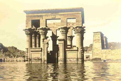
The Great Temple of Ramses II at Abu Simbe. The Kiosk of Trajan is in the foreground, while the Temple of Isis is at the right rear. The reservior of the first Aswan Dam flooded the complex for much of each year. Date and photographer unknown. Source: From the Collections of the Kelsey Museum - http://www.umich.edu/~kelseydb/Exhibits/AncientNubia/PhotoIntro.html
Ambitious rescue operations were begun in 1960, after an appeal by the Director-General of UNESCO (United Nations Educational, Scientific, and Cultural Organization). Twenty monuments from the Egyptian part of Nubia and four monuments from the Sudan were dismantled, relocated and re-erected. Many others were identified during the survey, and were documented before their subsequent inundation. Special permits were issued by the Egyptian and Sudanese governments for archaeological excavations conducted by multinational teams of researchers.
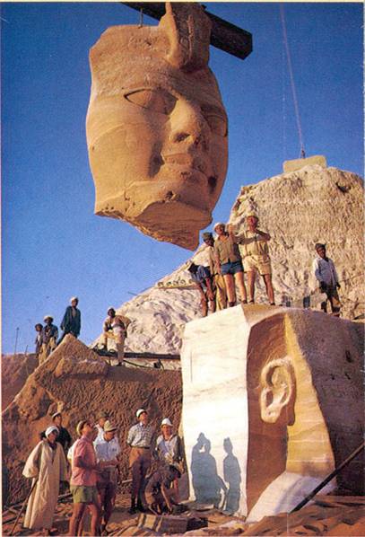
This statue was taken apart and moved from the Nile Valley onto the bluffs overlooking Lake Nasser in a last-minute effort by UNESCO. Source: http://carbon.cudenver.edu/stc-link/aswan1/culture.html
The Temples of Abu Simbel - built over 3250 years ago by Pharaoh Ramses II - were salvaged successfully. The effort involved moving 300,000 tons of rock, cutting the temple into over 1000 blocks and moving the pieces to higher ground. Many other sites were similarly relocated and are now preserved on the higher ground surrounding Lake Nasser. In the end, however, time ran out. It became clear that it would not be possible to document many of the sites of Lower Nubia completely, and that much of the information which careful archaeological excavation can yield would be lost forever.
Changes to the Egyptian fishing industry
One good aspect of the lake was to be its contribution to a new Egyptian fishing industry. However, weeds flourished in the reservoir, causing problems for the dam and the generators. Five years after the dam was built, two thousand fishermen managed to catch 3,628 tons annually, while the catch was expected to be around 20,000 tons. Ten years later the catch had dropped to 907 tons, and in 1978 the fisheries were so poor that only a small part of the population was able to live off fishing.
The effect of the dam on the Mediterranean fishing industry was more dramatic. The silt and sediments normally carried by the river contain important minerals and nutrients for fisheries in the sea at the river mouth. Unlike more fertile, nutrient-rich seas, such as the North Sea and the Arabian Sea, the Mediterranean is noted for its nutrient-poor waters that contribute to a low level of primary productivity. Primary productivity is the creation of organic matter through photosynthesis by unicellular organisms called phytoplankton. In the Mediterranean Sea, primary productivity is unusually low for several reasons. The circulation of the sea brings low-nutrient water from the North Atlantic through the Strait of Gibraltar, and allows nutrient-rich bottom water to exit the sea through the same opening. The arid climate of the region and the low levels of nutrient-rich river runoff also contribute to the low productivity of the Mediterranean.
Before the High Dam was built, fifty percent of the Nile flow drained into the Mediterranean. During an average flood, the total discharge of nutrient salts was estimated to be approximately 5,500 tons of phosphate and 280,000 tons of silicate. The nutrient-rich floodwater, or Nile Stream, was ~15 kilometers wide; it extended along the Egyptian coast and was detected off the Israeli coast and sometimes off southern Turkey.
The decrease in fertility of the southeastern Mediterranean waters caused by the High Dam has had a catastrophic effect on marine fisheries. The average fish catch declined from nearly 35,000 tons in 1962 and 1963 to less than one-fourth of this catch in 1969. Hardest hit was the sardine fishery: from a total of 18,000 tons in 1962, a mere 460 and 600 tons of sardine were landed in 1968 and 1969. The shrimp fishery also took a heavy toll as the catch decreased from 8,300 tons in 1963 to 1,128 tons in 1969.
In recent years there has been a noticeable increase in the sardine catch along the Egyptian coast (8,590 tons in 1992) with most of the landings coinciding with the period of maximum discharge from the coastal lakes during winter. Since the late 1980s, the total fish catch (pelagic and bottom) off the Egyptian coast has grown to levels comparable to those that existed before construction of the dam. Whether this is due to improved fishing efforts or recovery of fish stocks is not clear.
Erosion of the Delta
The reduced supply of silt and sediment from the annual flood has caused heavy erosion in the Nile Delta and as far away as Israel. The erosion, coupled with normal compaction of deltaic sediments, has decreased the inhabitable land on the Delta for the first time in over 10,000 years. The lack of silt reaching the Delta has made for a different set of problems farther upriver as well. The silt now gets trapped behind the Aswan Dam, where it settles out of the water and falls in thick layers on the floor of Lake Nasser. As a result, the reservoir becomes smaller each year, and is less able to handle the water and electricity-generation needs of the nation.
The Aswan Dam is hardly the only problematic example of engineering. Consider also the Kariba Dam, completed in 1959 across the Zambezi River. The purpose of the Kariba Dam was to provide electricity to the population and the industry of southern Zimbabwe, as well as to the copper mines in the north. Construction was started in 1956, financed by the largest World Bank loan ever. The dam was built by the British colonial government where the river formed the border between Northern and Southern Rhodesia (currently Zambia and Zimbabwe).
There are places in the world where dam building is not so problematical. Iceland, for example, has almost limitless hydroelectric power, and is working to dam many of the rivers in the country's interior. In this case, there are no people to resettle, and no international boundaries involved. The only "loss" is that of spectacular canyons and valleys, but there may be enough to go around.