Rift Lakes and Paleoclimate
The floor of the East African Rift is dotted with lakes. Take a look at a map of Africa and start counting and naming the lakes within the Rift from northern Ethiopia through Kenya and southward to Mozambique. Interestingly, the largest and best known African Lake ( Victoria) lies in a broad depression on the high topography of the Kenya plateau, rather than within the rift itself. So despite the major importance of Lake Victoria (its fishing industries are a significant economic driver in Kenya, Tanzania, and Uganda) we will not devote our attention to this lake.
Most of the Rift lakes are characterized by unusual chemical signatures and animal assemblages. Both of these features result from the isolation of the individual lakes: most of the lakes are not fed by major rivers (they catch rainfall from the surrounding slopes) and do not drain towards the ocean (they do not have river outlets). Water – and animal species – trapped within the lakes changes over time to reflect the unique features of elevation, topography, surrounding geology, and climate that define each lake.
Lake Tanganyika is the seventh biggest lake in the world, with an area of about 34 000 km². The lake is 650 km long and up to 60 km wide. The maximum depth is about 1470 metres (just about a mile), which ranks it as the second deepest lake of the world after Lake Baikal in Russia. Its borders are all steep faults that define the African Rift, and the lake itself is made up of several small basins connected together to form a single deep structure. Lake Tanganyika is one of the oldest lakes known on the planet. It has been isolated from the other African lakes for an extremely long time–at least 20 million years–and there are more than 200 different species of fish and mollusks that are found only in this one lake. The species are specialized to exist in many different micro-habitats of the lake shore, where steep rocky slopes dominate over shallow shorelines. Some fish species inhabit only a tiny fraction of the coastal region during the breeding and juvenile phases.
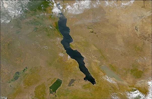
Satellite image of Lake Tanganyika. Source: NASA.
In addition to the many local habitats, Lake Tanganyika is characterized by some pretty unusual chemistry. Its pH has been measured to fall between 8.8-9.3 (remember that pH 7 represents a neutral solution, so the waters of Lake Tanganyika are quite basic, or “hard,” and are very rich in sodium, magnesium, and calcium). When scientists and explorers first came to Lake Tanganyika to make systematic surveys of the snails, fish, and crabs, they interpreted the lake as having been part of an ocean basin, because the animal life was so different from that found in African and European fresh-water lakes. Most of the water is estimated to be 20 million years old, having been trapped within the lake as it first formed, and it contains very little oxygen to support life; there is also a high content of hydrogen sulfide, which does not make the water suitable for most species. As a result, the lake is incredibly clear and clean, and you can see at least 20 meters down easily.