More Rift Lakes and Paleoclimate
To the south, Lake Malawi (Lake Nyasa) is the southernmost Rift lake. It is smaller and shallower than Lake Tanganyika, but is still the 9th largest lake in the world. To the north, Lakes Kivu, George, Edward and Albert complete the circuit of the Western Rift.
Great lakes of East Africa. Source: Badman's Tropical Fish.
In the following picture of Lake Kivu you can see clearly the steep rift walls that define the margins of each lake. Looking at a map, it is obvious that the Western Rift has more water than the Kenya or Ethiopian Rifts, reflecting simply the greater rainfall in this region. Remember that these Western Rift lakes (plus Lake Victoria) are the headwaters for the White Nile!

Lake Kivu (taken from Goma DRC), showing steep faulted Rift walls. Source: From the personal collection of Dr. Tanya Furman.
Lake Naivasha, Kenya, is unusual in having a rapid throughput of fresh water. In the photo below you can see the rich mats of papyrus that grow in the lake. This lake has abundant wildlife and is a significant watering place for people and animals in central Kenya simply because its water has a neutral pH and plenty of oxygen.
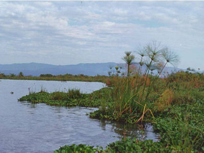
Papyrus on Lake Naivasha, central Kenya Rift. Source: From the personal collection of Dr. Tanya Furman.
In the northern part of the rift, low rainfall and high evaporation rates mean the lakes are very rich in salts and other mineral species. Lake Turkana in northern Kenya has a salt crust surrounding the lake shore, and Lake Abaya in Ethiopia is so full of bicarbonate that it makes a fantastic laundromat–water and cleanser all in one!
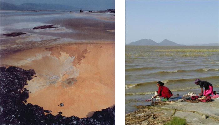
Lake Turkana (left) and Lake Abaya (right). Source: From the personal collection of Dr. Tanya Furman.
The Rift lakes contain a tremendous wealth of data about the climatic history of the region. Where do they hide that information? The sediments that accumulate on the floor of each lake contain pollen from the plants that grow on the surrounding slopes. When rain or wind brings tiny amounts of pollen to the lake surface, they eventually sink to the base of the lake and get buried within clastic sediments, or pieces of rock that are eroded from the steep walls as well. Over long periods of time (as we have seen for Lake Tanganyika we are talking about VERY long periods of time!), these sediments preserve a record of changes in the plant populations that live near the lake. Scientists can go to each lake, remove a column of sediments in a core, and examine them for the types of pollen found there through time. Each sediment core can contain information about tens of thousands of years of sedimentation and climate change. This week your activity involves having you examine some of their data from several Rift lakes, but first you will need a bit more background information.
The following images show ancient and modern pollen sites in Africa.
Fossil (ancient) Pollen Sites. Source: African Pollen Database.
Modern Pollen Sites. Source: African Pollen Database.
In addition to the lakes, recall that the African Rift is defined by volcanic activity. The areas labeled on the map below are volcanic areas located within the Western Rift. In addition to clastic sediments and pollen, the Rift lakes accumulate volcanic ash from these areas. The volcanic material is critical to our ability to understand climate change, because radiometric dating of ash and lava (remember that?) tells us exactly how old these materials are. We cannot obtain accurate dates on clastic sediments or on pollen, so we rely on the occasional volcanic sediment to find out the ages of individual layers in our sediment cores.
Map of East Africa showing some of the historically active volcanoes (red triangles) and the Afar Triangle (shaded, center) -- a so-called triple junction (or triple point), where three plates are pulling away from one another: the Arabian Plate, and the two parts of the African Plate (the Nubian and the Somalian) splitting along the East African Rift Zone.Source: VolcanoDiscovery.com.
Volcanic ash helps us date other events in the Rift as well. This image shows ancient footprints made by our earliest ancestors.
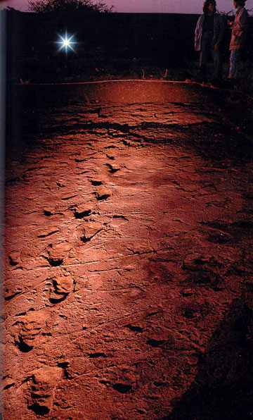
Laetoli steps—Preserved footprints in 3.6 Ma ash bed give evidence for early bipedalism. Source: From the personal collection of Dr. Tanya Furman.
We can determine the age of the ash very accurately, and learn from it that our ancestors walked upright as early as 3.6 million years ago. Without the volcanic ash, we could not date these footprints. In fact, volcanic activity throughout the Rift has helped constrain the timing of early hominid discoveries in many parts of Africa. Once we finish with our examination of the pollen evidence for climate change, we’ll return to the volcanoes.
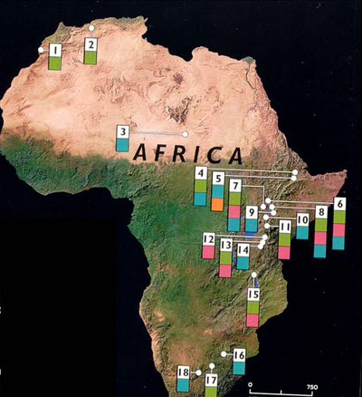
Map of hominid fossil sites, mainly in the Rift. Source: From the personal collection of Dr. Tanya Furman.