The White Nile
The two branches of the Nile have headwaters in areas of very different climate. The longer branch of the Nile—the White Nile—begins in the floor of the Western Rift, where it receives melt from glaciers and snowfields of the Ruwenzori Mountains (peaks of up to 5100 meters above sea level), as well as river drainage from Lakes Edward and Victoria. Lake Edward is the true headwaters of the Nile, because it is located farthest from the Nile delta. Lake Kivu, further south along the Zaire-Rwanda border, drained towards the Nile until roughly 15,000 years ago, when lavas from the Virunga volcanoes dammed the intervening river and forced the waters southward. All of the Rift lakes are steep sided, with the rift valley wall often rising straight up over 1000 meters from the lake floor.
Lake Victoria is one of the world's largest freshwater lakes. It lies in a broad plain between branches of the East African Rift system at an average elevation of 1300 meters above sea level (masl). Water leaving Lake Victoria forms several spectacular waterfalls, including the famous Murchison Falls, as it drops from 1140 to 710 meters above sea level, a change in elevation of 430 meters. This tributary, known locally as the Victoria Nile, next traverses marshy Lake Kioga—rich with water lilies and papyrus—before entering Lake Albert. The waters of the White Nile maintain a very steady flow rate because this region receives rainfall throughout the year, reaching a total between 1250 - 2000 mm/yr. The lakes themselves also help eliminate fluctuations resulting from local or seasonal rainfall variations.
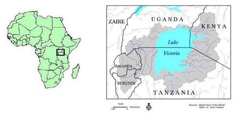
Africa and the Lake Victoria Basin. Source: Digital Chart of the World
The White Nile crosses the Sudd basin, a large and shallow area located in southern and central Sudan. The Sudd was once an isolated shallow lake with swamps, prior to coalescence along the course of the Nile. It is one of many large, shallow inland lakes that reflect the gentle topography of the ancient African continent. The river course is poorly defined in the Sudd, where riverbanks are made of decaying papyrus root masses, not rocks or soil. The banks are lined with living vegetation, primarily papyrus and thick grasses that grow up to 5 meters tall. From Juba (the southernmost corner of the Sudd), to Khartoum (1744 km downstream), the river elevation drops only from 450 to 375 meters above sea level. During this part of its journey, the White Nile is usually referred to as the Bahr el-Jebel. The thick papyrus disappears along this stretch on the river, and is replaced by bulrushes and reeds.
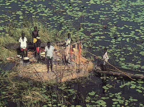
Fisherman in the Sudd. Source: H.H. Shugart, University of Virginia
 SIDEBAR: DID
YOU KNOW...?
SIDEBAR: DID
YOU KNOW...?
Based on the 1935 novel by C.S. Forester, "The African Queen" was released as the first color film in 1951 for leading actors Humphrey Bogart (Charlie) and Katharine Hepburn (Rose). This classic film combines adventure, comedy and romance as the Canadian scruffy drinking and smoking captain of a steamer (Bogart) travels downriver with the proper-yet-unorthodox African missionary spinster around the beginning of World War I. The film was shot almost entirely on location in Uganda and on the Lualaba River in the Democratic Republic of the Congo. The Lualaba is the headstream of the Congo River, running from the vicinity of Lubumbashi north to Kisangani, where the Congo officially begins. The Lualaba was once considered a possibility for the source of the Nile, until Henry Morton Stanley journeyed down it and proved otherwise.